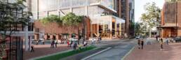
Increased Land Value and Potential Development Around Metro Stations
Historically, land around metro stations was unappealing to developers, investors and homeowners with a majority dissuaded due to increased traffic and sound pollution alike. The Transport Oriented Development (TOD) State Environmental Planning Policy (SEPP) will commence from April 2024 with property prices sure to increase around a selected number of metro stations in line with the radical changes to development standards and the paving of significant investment opportunities around rail stations. The selected metro stations are likely to become targeted areas for investors and developers with proprietors of once cheaper land set to see wind-fall gains for their properties.
- Part 1 is intended to focus on 8 accelerated precincts to create infrastructure and capacity
- Part 2 will focus on precincts that have existing infrastructure and located within 400 metres of 31 selected metro station.
Part 1 – Accelerated Rezonings – 8 Precincts
Land within 1,200 metres around train stations at Bansktown, Bays West, Bella Vista, Crows Nest, Homebush, Hornsby, Kellyvile and Macquarie Park will be rezoned by the NSW Government to increase housing supply and enable a variety of land uses (Residential, commercial and recreational). State Government expects development applications in these area to start being lodged from mid-2024 with the rezonings set to be completed by November 2024 which some rezonings completed earlier.
Development in these areas falling under the new SEPP will have DA time-limited for 2 years to encourage construction to occur earlier for faster delivery of housing. Applications for residential development with a capital investment value of less than $60M will be assessed by Council with a commitment of 90 days assessment timeframe.
Part 2 – Changes to SEPP – 31 Precincts
Planning controls introduced through the new SEPP will promote the faster delivery of more housing near public transport amenities and developed infrastructure in the following 31 locations:
- Corrimal
- Dapto
- Killara
- North Wollongong
- Ashfield
- Banksia
- Berala
- Canterbury
- Croydon
- Dulwich Hill
- Gordon
- Kogarah
- Lidcombe
- Lindfield
- Marrickville
- North Strathfield Metro
- Rockdale
- Roseville
- St Marys Metro
- Turrella
- Wiley Park
- Booragul
- Gosford
- Morisset
- Teralba
- Tuggerah
- Wyong
- Adamstown
- Hamilton
- Kotara
- Newcastle
- Interchange
- Corrimal
- Dapto
- Killara
- North Wollongong
- Ashfield
- Banksia
- Berala
- Canterbury
- Tuggerah
- Wyong
- Adamstown
- Hamilton
- Croydon
- Dulwich Hill
- Gordon
- Kogarah
- Lidcombe
- Lindfield
- Marrickville
- North Strathfield Metro
- Rockdale
- Roseville
- St Marys Metro
- Turrella
- Wiley Park
- Booragul
- Gosford
- Morisset
- Teralba
- Kotara
- Newcastle
- Interchange
The changes under the new policy will enable:
- Residential flat buildings in all residential zones (being R1, R2, R3 & R4) within 400m of the above stations; and
- Residential flat building and shop-top housing in local and commercial centres (i.e. E1 & E2 zoning) within 400m of the above stations.
The proposed changes to the planning controls are:
- Maximum building height of 21m (approximately 6 storeys)
- Floor space ration 3:1
- No minimum lot or width size
- Minimum active street frontage controls in E1 & E2
- Maximum parking rates
The planning policy is also set to introduce new design criteria for mid-rise residential apartment building being building separations, setbacks, vehicle access, visual privacy and communal open space.
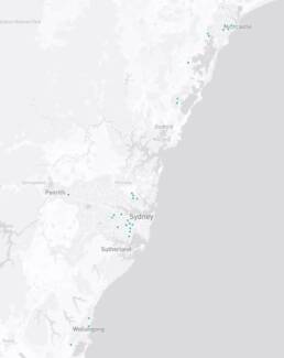
The above suburbs were selected after an analysis of 305 train, metro and intercity stations and have been nominated for having enabling infrastructure close to a transport station and their capacity to support additional housing growth. The NSW state government has continued to push for development to meet the housing demand, with phase-in discounts applying on infrastructure contribution plans up to June 2025. The changes are proposed to reduce urban spawl and ensure greater housing supply and increased density within walking distance of restaurants, open spaces, supermarkets and good public transport.
The introduction of the new SEPP alludes to increased housing prices in areas falling under the targeted growth precincts and while the state government is set to provide more affordable housing, coupled with the interest rates and increasing construction costs the effect might be quite to the contrary. For investors and developers alike, the above areas provide guidance on future growth and potential within NSW and areas which may see exponential increase in pricing.
For more information details on the Transport Oriented Development SEPP Click Here.